
LOUISVILLE, Ky. (WDRB) — Louisville area residents are bracing for what could be one of the most severe flooding events in the city’s recent history.
In response to growing viewer concerns and requests for clarity on just how bad things could get, WDRB’s Chief Meteorologist Marc Weinberg has introduced a new way to understand the flood risk across Kentuckiana.
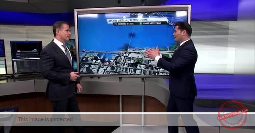
The WDRB exclusive Virtual Flood View is a tool that visually compares the area’s normal water levels to the forecasted flood stages expected in the coming days.
The virtual flood view allows residents to see a side-by-side projection of before-and-after flood conditions in key areas.
Weather Forecast | Live Cams | Radar | Share Photos & Videos
Louisville city leaders have already declared a state of emergency, and multiple road closures and evacuation preparations are already underway.
With another 4-6 inches of rain expected over the weekend, the Ohio River and its surrounding tributaries remain a major concern for both urban and rural parts of the region.
Officials are urging residents to stay informed, heed weather alerts, and avoid driving through flooded roadways, as even a few inches of moving water can be life-threatening.
Updated Information
A spokesperson for River House Restaurant has clarified that the business wouldn’t go under water. The river has to get to 47 flood stage for them to take on flood water.